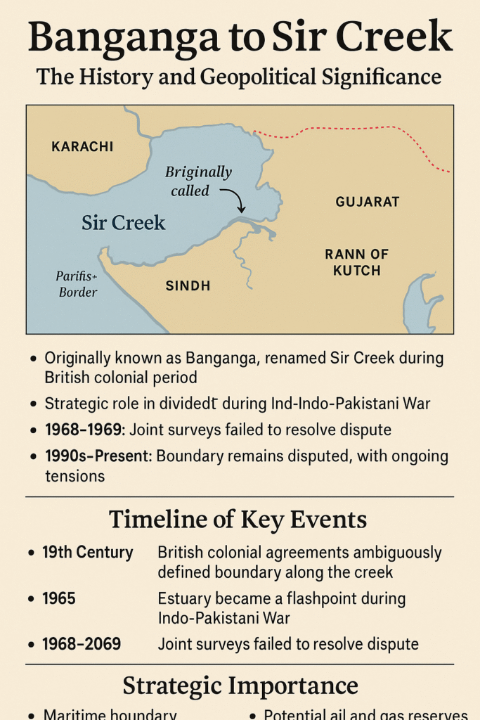
When one hears “Sir Creek,” it may sound like just another waterway on the India-Pakistan border. But the story of this 96-kilometer tidal estuary originally called Banganga is a tale of history, colonial legacy, and ongoing strategic significance. Stretching across the Rann of Kutch, dividing Gujarat in India and Sindh in Pakistan, this marshy expanse of mudflats has been the centre of territorial disputes, military planning, and economic ambitions for over a century.
Banganga: The Original Name
Before British surveyors arrived, the local communities referred to this creek as Banganga. The name resonates with local geography, connecting it to historic rivers and tidal channels feeding the Rann of Kutch.
However, during the 19th century, British surveyors remapped the region and renamed the estuary “Sir Creek”, which appears on colonial and modern maps. While the official name stuck, the local designation of Banganga reminds us that the creek’s story predates the geopolitical narratives imposed by colonial powers.
Historical Dispute: Colonial Ambiguity
The roots of the Sir Creek (Banganga) dispute trace back to British India:
- The British tried to demarcate boundaries between the Kutch princely state and Sindh, but the ambiguous language of agreements left room for differing interpretations.
- A 1914 agreement vaguely referred to the “mid-channel” of the creek, without a precise survey, leaving future generations with uncertainty.
After independence in 1947, India inherited Kutch and Pakistan inherited Sindh, but the Banganga/Sir Creek channel had shifted naturally over time, keeping the boundary issue unresolved.
Post-Independence Tensions
Though Sir Creek has never been the site of full-scale war, it has been a persistent flashpoint in Indo-Pakistani relations:
- 1965 War: Tensions over the Kutch region brought the creek into focus, though no major conflict occurred within the estuary.
- 1968–1969: Joint surveys were conducted, but Pakistan objected to India’s interpretation of the “mid-channel” as the boundary.
- 1990s–Present: Diplomatic negotiations continued intermittently, but the dispute remains unresolved, largely because the creek is a shifting tidal estuary, complicating precise demarcation.
Strategic Significance
Banganga/Sir Creek is more than just mud and water:
- Maritime Boundaries: Control over the creek determines parts of the Exclusive Economic Zone (EEZ) in the Arabian Sea.
- Fishing Rights: Local fishermen rely heavily on the waters of the creek, making sovereignty highly contested.
- Oil and Gas: Offshore exploration potential adds an economic dimension to the dispute.
- Military Geography: The route to Karachi, Pakistan’s major port, passes near the creek, enhancing its strategic significance.
Modern Military Developments
As of October 2025, the region has witnessed heightened military activity:
- India’s Trishul Exercise: India is conducting a large-scale tri-service military exercise (Trishul) from October 30 to November 10, 2025, around the Sir Creek/Banganga region. The drill aims to enhance coordination among the Army, Navy, and Air Force, focusing on joint operational readiness in this challenging terrain.
- Pakistan’s Response: Pakistan issued airspace restrictions in its central and southern regions, reflecting military sensitivity and signaling concern over the exercise.
- India’s Warning: Indian Defence Minister Rajnath Singh has cautioned Pakistan that any misadventure in the area would trigger a decisive Indian response, underlining the creek’s strategic importance.
Geopolitical Implications
The Banganga/Sir Creek issue is not merely a local border dispute; it embodies broader geopolitical dynamics:
- Bilateral Relations: The unresolved creek dispute feeds into overall India-Pakistan tensions.
- Economic Stakes: Fisheries, oil, and maritime control make the area valuable economically.
- Military Posturing: Regular exercises and patrols in the creek serve as demonstrations of strategic capability and readiness.
Experts note that any escalation could impact regional stability, particularly in the Arabian Sea and the wider Indian Ocean, where both nations project influence.
Conclusion: Banganga’s Enduring Legacy
The tidal estuary once known as Banganga is more than a border demarcation. It is a living testament to history, colonial legacies, and shifting geographies. Today, as Sir Creek continues to witness diplomatic caution, military drills, and strategic calculations, the name Banganga reminds us that the land and water belong to a history far older than modern borders.
Understanding this creek is crucial not just for geopolitics, but for appreciating the interplay of nature, history, and human ambition that shapes this sensitive region.